
Aimed at Research and Development, the site: www.madeinoff.com It was created to elaborate solutions aimed at improving the quality of life, facilitating the day-to-day of the users of its products both individually and collectively, besides attending the necessities of accessibility and sustainability. All the solutions that it presents do not have commercials of third parties and nor they aim at the commercial market, focusing their efforts on people of the most varied ages and interests. Being always ready to better serve your interests and develop new products or improve existing ones, simply contact us, we will respond as quickly as possible. After all, we need to live the dream of having a better life and, together, we will achieve this goal, bringing happiness to every moment of our lives. Here's a Bon Jovi song to encourage us at this point: !!! Livin' on a Prayer !!! Welcome to visit us.
Geographic coordinates are a system of imaginary lines drawn on the globe or a map.
It is through the intersection of a meridian with a parallel that we can locate each point on the Earth's surface.
Its coordinates are latitude and longitude and the principle used is graduation (degrees, minutes and seconds).
 The Coordinate System serves to locate points on the Earth's surface.
Example:
They are indicated by degrees of circumference.
A degree (1 °) equals one of the 360 equal parts in which the circumference can be divided.
A grade in turn is divided into 60 minutes (60 ') and each minute can be divided into 60 seconds (60 ").
Thus a degree equals 59 minutes and 60 seconds.
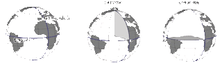
The Parallels
They are parallel lines to Ecuador, and the imaginary line of Ecuador itself is a parallel.
The 0º corresponds to the equator, the 90º to the north pole and the -90º to the south pole.
 The Meridians
They are lines perpendicular to the Equator that go from the North Pole to the South Pole and cross with the parallels.
All meridians are the same size and the starting point for meridian numbering is the meridian passing through the Greenwich Observatory in England.
Thus, the Greenwich meridian is the prime meridian (0 °).
To the east of Greenwich the meridians are measured by increasing values until 180º and, to the west, their measures are decreasing until the limit of -180º.
 From the meridians and parallels, the geographic coordinates that are measured in degrees have been established, and from the geographic coordinates it is possible to locate any point on the surface of the Earth.
Latitude and longitude
They are descriptions of the location, or geographic coordinates, of a particular place on Earth.
The way latitude is defined depends on the reference surface used, and longitude is measured in degrees from zero to 180 east or west from the Greenwich Meridian, and there is no natural starting position to mark the latitude and longitude.
 Latitude
It is the angle formed between the Equator and an estimated point.
The distance to Equator measured along the Greenwich meridian is calculated.
Therefore, all points in Ecuador have geographic latitude equal to 0º.
Points north of the equator have latitudes greater than 0º ranging up to 90º which is the latitude of the northern geographic pole.
As this distance is measured in degrees, it can vary between 0º and 90º for North (N) or for South (S).
Likewise, the latitudes to the south of the terrestrial equator vary from 0º to 90º, latitude of the south geographic pole.
It is measured north and south of the equator, between 90º south, in the South Pole and 90º north, in the North Pole.
In order to differentiate the values, a positive sign is given for the northern latitudes and negative for the southern latitudes.
Longitude
It is the distance to the Greenwich meridian measured along the Equator.
That is, it is the angle formed between the meridian passing through a certain place and the Greenwich meridian.
Thus, it represents the distance between a point and the Greenwich Meridian.
This distance is also measured in degrees, ranging from 0º to 180º to East (E) or West (W) of Greenwich.
By convention, signs for the lengths are also given:
 Longitude measurement is important for both cartography and safe ocean navigation.
Throughout history, many explorers have struggled to find a method of determining longitude, such as Amerigo Vespucci and Galileo.
However, the longitude calculation always presented serious problems, especially in the high seas.
Determining the latitude is simpler, just measure the angle between the horizon and the star with the help of a quadrant, astrolabe or sextant.
The localization
There are at least four ways of assigning an exact location to any point on the surface of the globe.
In the first three systems, the globe is divided into latitudes, ranging from 0 to 90 degrees (north or south) and longitudes, ranging from 0 to 180 degrees (East or West).
For practical purposes, the international acronyms for the cardinal points are used:
The value of each unit is well defined, since half of the large circle has 20003.93km, dividing the latter by 180, it is concluded that a degree (°) is equivalent to 111,133 km.
Dividing a degree by 60, one minute (') is equivalent to 1852.22 m (practically the same value as the nautical mile).
Dividing one minute by 60, we have that one second (") is equivalent to 30.87 m,
For Latitudes
There is a specific value for each position, which increases from 0 in the Equator Line to the Poles, where its maximum value is (90 ° angle amplitude).
Keep in mind that the Latitude and Longitude coordinates can take these three different formats:
From there, the seconds can be divided decimally into smaller and smaller fractions.
Degrees (g.g°)
Like for example:
Like for example:
Like for example:
Decimal Minutes
In this system, each degree is divided into 60 minutes, which in turn are divided decimally.
Decimal Degrees
In this system, each degree is divided into decimal fractions.
The form of appointment differs somewhat from the first two systems:
The negative values are for the South (latitude) and the West (longitude), being added the symbol -.
Universal Transverse Mercator
For comparison purposes, this system uses three data instead of two. The first is the sector of the terrestrial globe, the second is the distance relative to the center of the meridian - always 500,000.00 m - and the third is the distance from the South Pole (to places in the Southern Hemisphere) or the Equator (for places In the Northern Hemisphere).
You might also like to know:
One of the best ways to locate yourself is by using the Aki application.
 You can learn more about it by visiting:
It is through the intersection of a meridian with a parallel that we can locate each point on the Earth's surface.
Its coordinates are latitude and longitude and the principle used is graduation (degrees, minutes and seconds).

Example:
Point A: Latitude 50 ° N; Longitude 100º O
The Parallels and the MeridiansThey are indicated by degrees of circumference.
A degree (1 °) equals one of the 360 equal parts in which the circumference can be divided.
A grade in turn is divided into 60 minutes (60 ') and each minute can be divided into 60 seconds (60 ").
Thus a degree equals 59 minutes and 60 seconds.
The Parallels
They are parallel lines to Ecuador, and the imaginary line of Ecuador itself is a parallel.
The 0º corresponds to the equator, the 90º to the north pole and the -90º to the south pole.

They are lines perpendicular to the Equator that go from the North Pole to the South Pole and cross with the parallels.
All meridians are the same size and the starting point for meridian numbering is the meridian passing through the Greenwich Observatory in England.
Thus, the Greenwich meridian is the prime meridian (0 °).
To the east of Greenwich the meridians are measured by increasing values until 180º and, to the west, their measures are decreasing until the limit of -180º.

Latitude and longitude
They are descriptions of the location, or geographic coordinates, of a particular place on Earth.
The way latitude is defined depends on the reference surface used, and longitude is measured in degrees from zero to 180 east or west from the Greenwich Meridian, and there is no natural starting position to mark the latitude and longitude.

It is the angle formed between the Equator and an estimated point.
The distance to Equator measured along the Greenwich meridian is calculated.
Therefore, all points in Ecuador have geographic latitude equal to 0º.
Points north of the equator have latitudes greater than 0º ranging up to 90º which is the latitude of the northern geographic pole.
As this distance is measured in degrees, it can vary between 0º and 90º for North (N) or for South (S).
Likewise, the latitudes to the south of the terrestrial equator vary from 0º to 90º, latitude of the south geographic pole.
It is measured north and south of the equator, between 90º south, in the South Pole and 90º north, in the North Pole.
In order to differentiate the values, a positive sign is given for the northern latitudes and negative for the southern latitudes.
Longitude
It is the distance to the Greenwich meridian measured along the Equator.
That is, it is the angle formed between the meridian passing through a certain place and the Greenwich meridian.
Thus, it represents the distance between a point and the Greenwich Meridian.
This distance is also measured in degrees, ranging from 0º to 180º to East (E) or West (W) of Greenwich.
By convention, signs for the lengths are also given:
negative for west and positive for east
By having the latitude and longitude values of a desired location, we will have determined the geographical coordinates of the same.
Throughout history, many explorers have struggled to find a method of determining longitude, such as Amerigo Vespucci and Galileo.
However, the longitude calculation always presented serious problems, especially in the high seas.
Determining the latitude is simpler, just measure the angle between the horizon and the star with the help of a quadrant, astrolabe or sextant.
The localization
There are at least four ways of assigning an exact location to any point on the surface of the globe.
In the first three systems, the globe is divided into latitudes, ranging from 0 to 90 degrees (north or south) and longitudes, ranging from 0 to 180 degrees (East or West).
For practical purposes, the international acronyms for the cardinal points are used:
- N = North;
- S = South;
- E or L = East;
- O or W = West.
The value of each unit is well defined, since half of the large circle has 20003.93km, dividing the latter by 180, it is concluded that a degree (°) is equivalent to 111,133 km.
Dividing a degree by 60, one minute (') is equivalent to 1852.22 m (practically the same value as the nautical mile).
Dividing one minute by 60, we have that one second (") is equivalent to 30.87 m,
For Latitudes
There is a specific value for each position, which increases from 0 in the Equator Line to the Poles, where its maximum value is (90 ° angle amplitude).
Keep in mind that the Latitude and Longitude coordinates can take these three different formats:
Degrees, Minutes, Seconds
In this system, each degree is divided into 60 minutes, which in turn are subdivided, each in 60 seconds.From there, the seconds can be divided decimally into smaller and smaller fractions.
Degrees (g.g°)
Like for example:
49.5000°, -123.5000°
Minutes (gºm.m')Like for example:
49°30.0', -123°30.0'
Seconds (g°m's'')Like for example:
49°30'00"N, 123°30'00"W
Besides this, it can also be:Decimal Minutes
In this system, each degree is divided into 60 minutes, which in turn are divided decimally.
Decimal Degrees
In this system, each degree is divided into decimal fractions.
The form of appointment differs somewhat from the first two systems:
latitude is given the abbreviation lat and longitude, long
There are positive and negative values. Positive values are for North (latitude) and East (longitude) and do not receive a specific symbol -.The negative values are for the South (latitude) and the West (longitude), being added the symbol -.
Universal Transverse Mercator
For comparison purposes, this system uses three data instead of two. The first is the sector of the terrestrial globe, the second is the distance relative to the center of the meridian - always 500,000.00 m - and the third is the distance from the South Pole (to places in the Southern Hemisphere) or the Equator (for places In the Northern Hemisphere).
You might also like to know:
One of the best ways to locate yourself is by using the Aki application.
Comentários
Postar um comentário